Karakoram Highway
Cycle the legendary Karakoram Highway from Pakistan to Kyrgyzstan, crossing high passes and vast mountain landscapes in three epic countries.
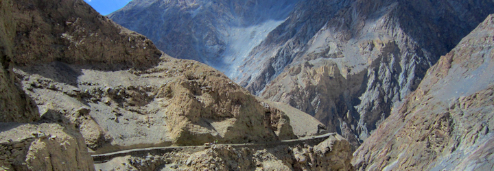
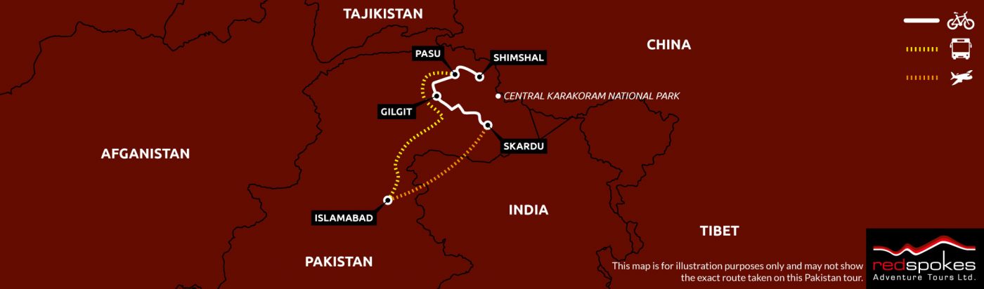
The redspokes Pakistan cycling tour explores the dramatic landscapes of the Karakoram, one of the world’s greatest mountain regions. Home to towering 7,000–8,000m peaks including K2, vast glaciers and striking black-rock river valleys, this journey delivers some of the most awe-inspiring riding on Earth. From Gilgit, the route climbs through the Bagrote Valley and into the heart of these immense mountain ranges.
Cycling onward to Shimshal, the highest settlement in the Hunza Valley, riders experience remote communities renowned for their hospitality and rich cultural heritage. With ever-changing scenery, thrilling descents and unforgettable Himalayan vistas, this tour offers a rare opportunity to ride through one of the planet’s most spectacular and storied landscapes.
This flight must be one of the most exciting in the world, the small Fokker Friendship plane flies around the 8,125m (26,660ft) Nanga Parbat.
The pilot sometimes invites passengers into the cockpit to see some of Pakistan’s 82 peaks over 7,000m (23,000ft), which stretch, range after range, as far as the eye can see.
The sharp triangle of K-2, the second highest mountain in the world, is clearly visible on the horizon.
At an elevation of 1,500m lies the Gilgit valley, offering spectacular scenic beauty. It is surrounded by lakes, rivers, glaciers and high mountains ranges. Some of the world’s largest peaks, such as Nanga Parbat (8,125m) and Raka Poshi (7,788m) are located here.
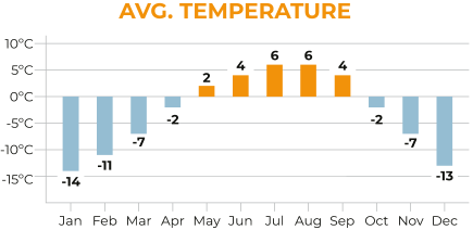
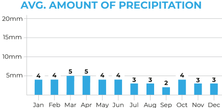
The best season to visit is from May to mid-October. The local dialect is Shina, however, Urdu and English are also spoken and understood.
The 1950s and 1960s were the era of the ‘new town’ a concept first elaborated in Britain after World War II under the banner ‘Homes fit for heroes to live in!’ This idealism underpinned the Pakistan government’s decision to construct Islamabad to replace Karachi as its capital city.
Work started in 1961 and is still far from finished. Wide Roads, detached houses and gardens contrast somewhat with the old Pakistani city.
Places of interest include Pakistan’s largest mosque: Faisal Mosque and the Lok Virsa Museum where you’ll see an interesting collection of folk and traditional artefacts, green spaces. Just an hour by taxi from Islamabad is the UNESCO World Heritage site Taxila. Meaning “City of Cut Stone” or “Takṣa Rock”, Taxila is an important archaeological site where you can see remains of four early settlement sites, Buddhist monasteries, and a Muslim mosque and Madrassa.
Islamabad’s twin city Rawalapindi only 15 km away, has crowded, narrow winding bazaars and ancient buildings huddled together.
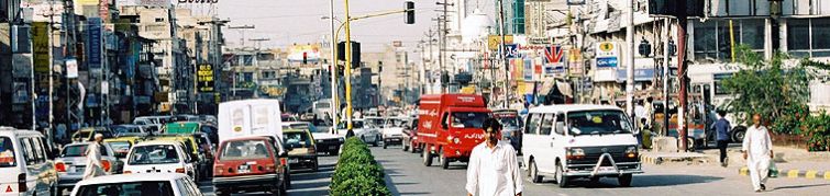
A visit the bazaar in the old city of Rawalpindi; wandering through the Saddar and Rajab Bazaar is what visiting a Pakistani city is all about.
This, as opposed to the planned wide open Islamabad is how a traveller imagines an eastern city to be.
Witness the interesting chaos in the narrow crowded streets with vendors selling jewellery, brass, copper and Kashmiri embroidery. In fact it is possible to buy almost anything!
You can’t fail to be impressed by Islamabads remarkable mosque; said to be the biggest in Asia with room for 100,000 worshippers.
It was designed by the renowned Turkish architect Vedat Daloky and named after the late King Faisal of Saudi Arabia, who contributed most of the 50 million dollar cost.
Arrive at Islamabad airport. Complementary airport to hotel transfers are included for all flight times. At 6pm you will meet the group and our representative at the hotel for a briefing.
Islamabad Altitude: 540 metres (1,770 ft)
Accommodation: Hotel (D)
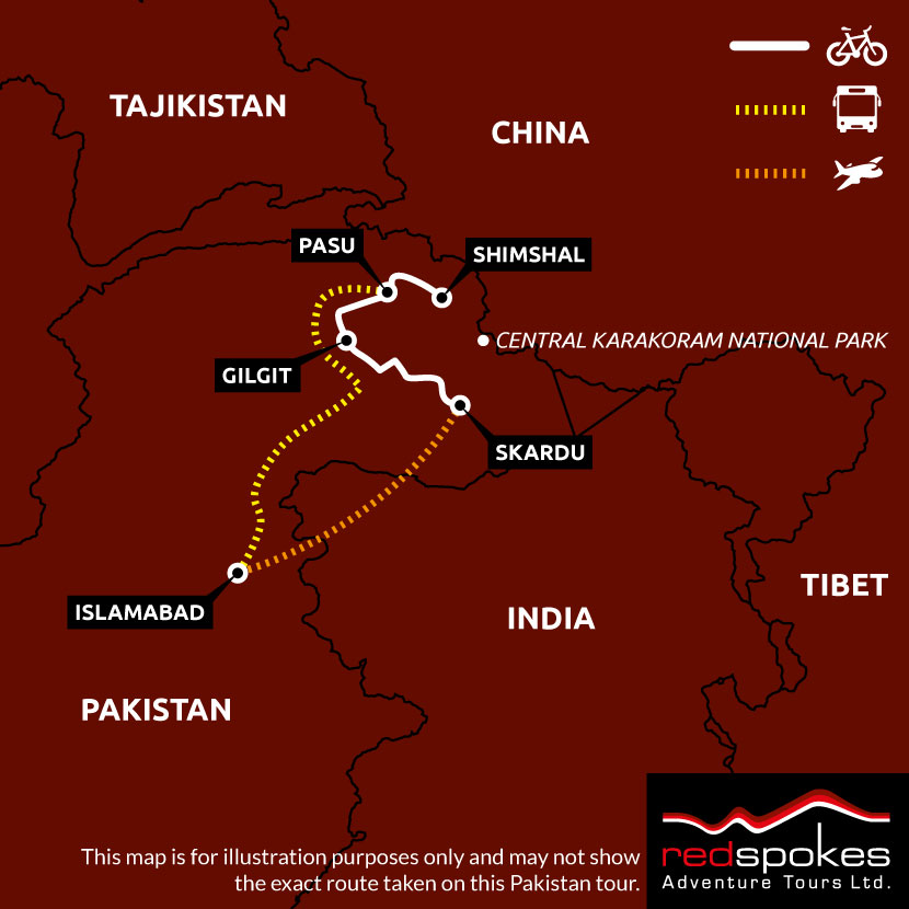
This morning, we aim to take the early flight from Islamabad to Gilgit (not included in the trip cost). This is one of the most scenic and exhilarating flight routes in the world. The journey offers breathtaking aerial views of Pakistan’s northern mountain ranges, including Nanga Parbat (8,125m), and on a clear day, even the distant silhouette of K2, the world’s second-highest peak.
The flight is operated using ATR 42-500 twin-engine turboprop aircraft. These planes are ideal for short-haul routes and are specifically suited to navigate the challenging approach into Gilgit Airport, which lies at 4,796 feet above sea level and has a relatively short runway at 5,400 feet.
Please note, this route is weather dependent, and while the flight is scheduled to operate, cancellations do occur, occasionally at the last minute. In the event the flight is cancelled, we will continue our journey to Gilgit by road, taking in the dramatic landscapes of the Karakoram region along the way.
Upon arrival in Gilgit—whether by air or road—you’ll be transferred to the group hotel for check-in and some time to relax.
Gilgit Altitude: 1,462m (4,796ft)
Accommodation: Hotel (L,D)
Today offers a relaxed start, with time to acclimatise and get comfortable on the bikes. We’ll take a gentle 18km warm-up ride around Gilgit, visiting the impressive 7th-century Kargah Buddha, carved into a cliff face just outside the town. Nearby, at Shuko Gah, is the site where the ancient Gilgit Manuscripts, some of the oldest Buddhist texts in the world, were discovered.
You’ll also have free time to explore the town’s bazaars or unwind at the Serena Hotel, our comfortable base in Gilgit.
Gilgit Altitude: 1,462m (4796ft)
Cycle Distance: 18km (11 miles)
Total Climb: 225m (738ft)
Total Descent: 225m (738ft)
Accommodation: Serena Hotel (B)
Today we set off on the bikes and cycle into the beautiful and remote Bagrote Valley which spans a distance of 25km and is 43km from Gilgit. Located at the heart of the Karakorum Mountains, it is surrounded by four Mountain Peaks: Rakapushi to the West, Dirn to the North, Popurash to the East and Dubani to the South East. The Bagrote River flows through the steep valley and merges with the Gilgit. The lower region of the valley has been likened to a lunar landscape and is in strong contrast to the upper valley. We cycle up the narrow road to the summer pastures passing beautiful terraced fields and meadows. The crops and orchards are irrigated by water channels from the Barchi and Hinarchi glaciers and mountain snow. Ice from the glacier is transported to Gilgit as the town has no ice factory. Chirah is the final village along the track, with a view of Hinarche Glacier and a series of ridges culminating in the Diran Peak (7270m). Nagyr is on the other side. Tonight we will be camping.
Chirah Altitude: 2,390m (7,841ft)
Cycling Distance: 34km (21 miles)
Total Climb: 1,240m (4,068ft)
Total Descent: 450m (1,476ft) Accommodation: Camping (B,L,D)
This morning we visit the local school and women’s sewing centre, a vocational training project; both are supported by redspokes LVCF charity. We have the opportunity to meet families from the community. There is time to walk around and enjoy the view of the prominent Dobani peak and the Hinarche Glacier. We cycle back to Gilgit, mainly downhill; a gentle trip compared with yesterday’s ascent up the valley. Back in Gilgit you will have time to look around, visit a tea shop or pick up some of the handicrafts for sale in the town.
Gilgit Altitude: 1,462m (4796ft)
Cycle Distance: 43km (27 miles)
Total Climb: 450m (1,476ft)
Total Descent: 1,240m (4,068ft)
Accommodation: Serena Hotel (B,L)
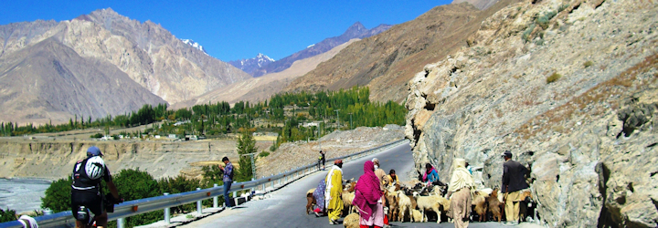
Shortly after leaving Gilgit, we rejoin the legendary Karakoram Highway as it begins a gentle ascent, winding through a series of small villages and terraced fields. Along the way, there are fleeting glimpses of Rakaposhi’s immense, spiraling form, but much of its grandeur remains hidden behind the ridgelines.
It’s only when we arrive at the newly opened Dumani Nagar Hotel & Resort, nestled almost at the mountain’s base, that Rakaposhi reveals itself in all its breathtaking glory. This elegant 5-star retreat offers sweeping panoramic views and is surrounded by beautifully landscaped gardens filled with cherry and apricot trees. Seamlessly blending modern comfort with the wild, dramatic beauty of the Hunza Valley, it’s a stunning addition to the region and a truly unforgettable setting.
Jafarabad Altitude: 925m (3,035ft)
Cycle Distance: 57.9km (36 miles)
Total Climb: 1,530m (5,019ft)
Total Descent: 1,150m (3,772ft)
Accommodation: Hotel and Resort (B,L,D)
We begin the day crossing the Hunza River en route to Hussain Abad, a peaceful Ismaili Muslim village known for its strong sense of community and commitment to education and social development, inspired by the values of the Aga Khan.
In 2010, the village was hit by devastating floods and a landslide that displaced 50 families. With support from redspokes donors and in collaboration with the Aga Khan Foundation, new homes were built on safer ground. When redspokes founder Dermot MacWard returned with a group of cyclists in 2013, they received a warm and emotional welcome, captured in this video.
From Hussain Abad, we follow a stunning stretch of road along the north side of the Hunza River, with dramatic views of the valley below. The day ends in the beautiful town of Karimabad, nestled high above the valley with sweeping views of Rakaposhi, Ultar Sar, and Ladyfinger Peak—a perfect place to unwind after a meaningful day’s ride.
Karimabad Altitude: 2,400m (7,874ft)
Cycle Distance: 46.75km (29 miles)
Total Climb: 1,230m (4,035ft)
Total Descent: 890m (2,919ft)
Accommodation: Hunza Serena Hotel (B)
Although it’s a rest day, Karimabad has a way of pulling you out to explore. With its rich history and incredible setting, it’s unlikely you’ll stay still for long.
You can visit the iconic Baltit Fort, perched above the town with commanding views and centuries of Hunza history within its stone walls. Nearby, the Sacred Rocks of Hunza, covered in ancient petroglyphs and inscriptions, offer a glimpse into the region’s role along the old Silk Road.
For those feeling adventurous, a trek up to Hon Village rewards you with stunning views over the Nagar Valley and the surrounding peaks. Or simply wander the village, sip chai, and soak up the scenery—Rakaposhi, Ultar Sar, and Ladyfinger Peak keeping watch in the distance.
Karimabad Altitude: 2,400m (7,874ft)
Accommodation: Hunza Serena Hotel (B)
Refreshed from our time in Karimabad, we set off north along the Karakoram Highway through the striking upper Hunza region. The ride takes us past the vivid turquoise waters of Attabad Lake, created by a landslide in 2010, and through dramatic tunnels carved into the mountainside.
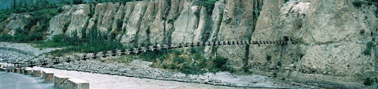
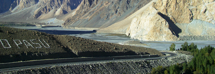
We’ll make a stop at the photogenic Hussaini Suspension Bridge before continuing to Passu, a quiet village nestled beneath the iconic Passu Cones. Surrounded by glaciers, jagged peaks, and the winding Hunza River, this is one of the most breathtaking sections of the journey.
Passu Altitude: 2,480m (8136ft)
Cycle Distance: 51.4km (32 miles)
Total Climb: 1,220m (4,002ft)
Total Descent: 1,100m (3,641ft)
Accommodation: Hotel (B,L)
Today we leave the main road behind and head deep into the remote Shimshal Valley. The journey into this secluded mountain region is by vehicle, though those seeking a serious challenge can choose to cycle unsupported along the narrow, winding track—carved dramatically into the cliffs above the Shimshal River. It’s an incredible route, often described as a miracle of engineering.
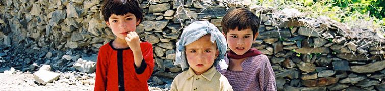
As we ascend into the valley, the scenery becomes increasingly rugged. Dry stone walls divide fields of barley and potatoes, while mud-and-stone houses blend into the rocky landscape. If visibility is good, we may catch a glimpse of Odver Sar (6,303m) in the distance. The people of Shimshal are Wakhi, a hardy and hospitable community whose way of life is closely tied to the mountains. Many still practice traditional herding, with yaks, goats, and sheep moved between high pastures and the valley floor depending on the season.
Accommodation here is basic, but the experience of staying in one of Pakistan’s most isolated mountain communities is a rare and special one.
Shimshal Altitude: 3,100m (10,170ft)
Cycle Distance: 59km (37 miles)
Total Climb: 2,310m (7,578ft)
Total Descent: 1,720m (3,280ft)
Accommodation: Guest House (B,L,D)
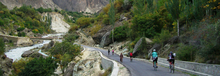
After experiencing life in Shimshal, we begin our descent—this time on two wheels. The ride out of the valley is spectacular, passing through remote alpine terrain with barely a trace of permanent settlement. We cycle past the icy tongue of the Mulungutti Glacier and weave through a landscape shaped by water, stone, and time.
Apart from the occasional shepherd’s hut, the valley is wild and untouched. Herds of yak, goats, and sheep roam the slopes, watched over by herders who follow age-old seasonal routes.
Eventually, we cross the Hunza River via a suspension bridge and rejoin the Karakoram Highway, around 6 km north of Passu. From here, we transfer by vehicle to Gulmit, a peaceful village set beneath the dramatic peaks of Upper Hunza.
Passu Altitude: 2,480m (8136ft)
Cycle Distance: 59km (37 miles)
Total Climb: 1,720m (3,280ft)
Total Descent: 2,310m (7,578ft)
Accommodation: Hotel (B,L)
Today we continue cycling south along the Karakoram Highway, retracing our route through the dramatic landscapes of the Hunza Valley. With towering peaks above and the Hunza River below, this stretch is every bit as scenic the second time around.
The road is lined with apricot trees and small stone-built villages, with warm waves from locals as we pass. Along the way, we enjoy another spectacular view of Rakaposhi (7,788m)—one of the tallest mountains on Earth when measured from base to summit, rising nearly 6,000 metres in a single sweep.
By late afternoon, we arrive once again in Jafarabad, where we settle back into the comfort of the Dumani Nagar Hotel & Resort for the night.
Jafarabad Altitude: 1,983m (6,505ft)
Cycling Distance: 85.3km (53 miles)
Total climb: 1,680m (3,280ft)
Total descent: 2,170m (7,119ft)
Accommodation: Hotel and Resort (B,L,D)
We will trek around the local area this morning. We are surrounded by steep hillsides where small conifers grow. The village of Minapin is a popular destination as it provides the easiest access to three peaks that mountaineers are fond of scaling: the 7,788m Rakaposhi peak, the 7,266m Diran peak and the Miachar peak in the Karakoram Range. The valley’s natural beauty and the hospitality, culture and traditions of the locals all contribute to its popularity. The valley is also known for an abundance of fruit production, including apricots, apples, mulberry, walnuts and pomegranates.
Jafarabad Altitude: 1,983m (6,505ft)
Accommodation: Hotel and Resort (B,L,D)
This morning, the group will begin the journey back to Islamabad by road — a scenic but long drive that typically takes around 14 hours.
Alternatively, you may choose to book a morning flight from Gilgit to Islamabad (not included in the tour cost). This flight is currently scheduled to depart at 09:05 am, with a flight time of approximately 1 hour and 15 minutes. Flying offers a more relaxed return, giving you the opportunity to spend the afternoon exploring some of Islamabad’s key attractions — such as the iconic Faisal Mosque, the fascinating Lok Virsa Museum, or the nearby UNESCO World Heritage site of Taxila.
Please be aware that in the unlikely event of flight cancellation, the return journey will be made by road instead.
To allow for any unforeseen delays, we strongly recommend booking your international departure flight no earlier than 12:00 pm (midday) on the final day of the itinerary.
Accommodation: Hotel (B)
Transfer to airport for our late afternoon/evening flight home.
(B)
The above itinerary is intended as a working guide. Although every effort will be made to adhere to it, changes may be made because of weather conditions, transport failure or other unforeseen events.
Tour Status Definitions
Booking & Payments
Small Group Note
For groups of fewer than four participants, the guide may lead from the support vehicle rather than cycling with the group, ensuring full logistical and guiding support.
Fully supported cycling holiday
Meal Key (used in the itinerary)
Tour Start
Tour End
Flights
On-Ride Support
Helmet Policy
Pre-trip bike servicing
We strongly recommend having your bike fully serviced before travelling. Please make sure:
What to bring
We recommend packing the following essential items:
Travelling with your bike
Your bike will need to be packed within your luggage allowance. A bike packed in a cardboard box typically weighs between 15–20 kg, and some airlines may charge excess baggage fees.
If you would prefer not to travel with your own bike, bike hire is available — simply request this when booking.
Spending Money
Staff Tipping
Travel Insurance
Mandatory for all participants and must cover:
Health & Vaccinations
Staying Hydrated on Hot Rides – 6 Tips for Cyclists
As a cycling company, we know how important proper hydration is—especially when you’re out riding in hot conditions. Below are some general hydration tips that riders find helpful for staying fuelled and feeling strong on the bike.
Please note: We are not medical professionals and this information should not replace advice from a qualified healthcare provider. Each cyclist is different, so if you have specific health concerns or conditions, it is always best to consult your doctor and adhere to their advice.
1. Prioritize Gut Health
2. Time Your Hydration
3. Hydrate Beyond Water
4. Don’t Forget the Minerals
5. Absorb Water Better
6. Keep Your Electrolytes in Check
First Aid Kit
Our guides carry first aid supplies, however we recommend you bring your own first aid kit which should contain the following items:
Miscellaneous
Our professional cycling tops are designed with three rear elasticated pockets to give you plenty of space for your cycling essentials and comes with a silicone bottom hem. Lined with COOLMAX ® to keep you cool and comfortable and ensure moisture wicking. Available in varies sizes so please refer to size charts for more information.
This is one of redspokes’ highest-standard adventure tours, combining premium hotels in the cities and major valleys with a handful of simple guesthouses and camping nights in the most remote mountain regions.
In Islamabad we use The 108 Hotel, and in Gilgit the Gilgit Serena Hotel, both offering modern rooms, excellent service and a calm base before and after time in the high mountains. In Skardu and Shigar, nights are spent at comfortable local properties such as Concordia Motel Skardu and (when available) the atmospheric Shigar Fort Residence – Serena Hotel or Shigar Space Hotel. Higher in Hunza, we stay at well-regarded hotels like Hill Top Hotel, Karimabad and Darbar Hotel, Passu, all with private facilities and superb views of the surrounding peaks.
As we head deeper into the Karakoram, the standard naturally becomes more traditional. In villages such as Askoli, Thowar and Bagrot, accommodation is in simple guesthouses, government rest houses or supported camping, and in Shimshal we use the Shimshal Tourist Lodge – basic but welcoming, with shared or more limited facilities. These nights are chosen not for luxury, but for their access to spectacular high-mountain landscapes and local village life.
Expect:
Here are a selection of videos for our ‘Pakistan – The Old Silk Route’ Cycling holiday.


Cycle the legendary Karakoram Highway from Pakistan to Kyrgyzstan, crossing high passes and vast mountain landscapes in three epic countries.

Luxury cycling in Pakistan’s Karakoram Mountains, riding the legendary Karakoram Highway beneath 7,000m peaks.